 The Fort River and its upper reaches (Amethyst Brook and Hop Brook) have numerous public access points suitable for hiking, dog-walking, nature viewing, fishing, wading, and paddling. Some areas are ADA accessible. When you visit the river, please be respectful, safe, and do your best to leave-no-trace.
Suggestions for Enjoying the Fort River Safely
- Only use the marked parking areas and access points, and honor areas that are marked as being off limits.
- Follow park rules.
- Respect private property.
- Don’t leave your litter, and safely pick up any trash that you find.
- Pick up after your dogs – dog poop contributes to river pollution and can transmit parasites to wildlife and humans.
- Protect vegetation from trampling by sticking to trails.
- Minimize erosion by leaving rocks and plants in place, staying on trails and using clearer areas to access the water.
- If you use bug spray — stay out of the water! Most bug sprays are very toxic to aquatic organisms.
- Check for ticks after any explorations (more information here on how to identify and remove them).
- Watch out for poison ivy (more information here on how to identify it).
Explore the interactive map to learn about some of our favorite places to visit in the Fort River watershed.
In Amherst:
- Amethyst Brook Conservation Area: Amethyst Brook originates in Pelham and flows into the Fort River. The conservation area has an extensive network of trails for walking, running, dog-walking, and biking. Cross-country skiing is possible in winter. Trailhead parking on Pelham Road.
- Groff Park: The Fort River is wide and shallow as if flows through Groff Park in Amherst. The park offers many amenities including a newly improved playground and wading pool, picnic areas, ballfields, and access to the Emily Dickinson Trail. Pavilion reservations possible through the Amherst LSSE. Parking at 72 Mill Ln.
- Wentworth Farm Conservation Area: This conservation land has a mixture of forest, meadow, and marshy areas. Excellent for walking, running, and dog-walking. The Fort River passes along the north side of the park, and is seen best from the walking trail bridge connecting Wentworth Farm to the Stanley Street ballfields. Parking at the Kiwanis Field at 137 Stanley St. or off Old Farm Rd.
- Emily Dickinson Trail: The Emily Dickinson Trail is a well-maintained, 1-mile, dirt walking trail connecting Groff Park to the Norwottuck Trail parking area on Southeast Street. The trail follows the Fort River and has several footbridges over the small creeks entering the Fort. Parking at Southeast Street or Groff Park.
- Harvey Allen Trail: A singletrack dirt trail connects from the end of the Emily Dickinson Trail at Southeast Streeet to the Wentworth Farm Conservation area. The trail crosses a branch of the Fort River. This is a popular birding area, and beaver activity is commonly seen. Parking at Southeast Street or Kiwanis Park.
- Lawrence Swamp and Hop Brook: Hop Brook is a tributary of the Fort River that flows through the Lawrence Swamp area of Belchertown and South Amherst. The Norwottuck Rail Trail passes through the swamp, offering spectacular views of marsh and prairie ecosystems. The ADA accessible trail is suitible for walking, running, biking, birding, and more. Additionally, the Robert Frost hiking trail passes through the southern, forested portion of Lawrence Swamp, crossing several small streams. Parking for the Nortowttuck Rail Trail is available at Southeast Street, Lawrence Station, and off Warren Wright Road.
- Hickory Ridge: In September, 2019, the Amherst Town Council announced it would like to purchase 150 acres of land operated as the Hickory Ridge Golf Course. Approximately one mile of the Fort River passes through the land. While the deal is not yet complete, proposals for solar development, affordable housing, and conservation land could mean that the area may evolve into an ideal place for walking, hiking, and enjoying the river.
In Hadley
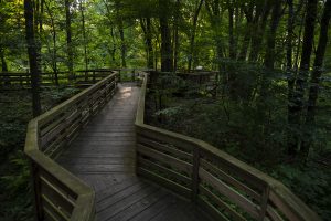
- Silvio O. Conte National Wildlife Refuge: The Fort River Nature Trail meanders in a 1.2 mile loop through the Silvio O. Conte refuge in Hadley. The trail passes through bogs and forests and along the Fort River. It is fantastic for viewing wildlife, walking, jogging, and cross country skiing. The trail is wide, flat, and parts are constructed with boardwalks, making it universally accessible. There are also benches and educational kiosks along the path. Parking at Moody Bridge Rd., Hadley.
In Pelham
Cadwell Memorial Forest: The Cadwell forest offers casual hiking, biking, or cross country skiing through the upper headwaters of the Fort River. The forest is owned by the University of Massachusetts and is managed as a natural laboratory for forestry management. There is a mix of hemlock, white pines, and oaks, while beaver dams can be seen along Harris Brook before it flows into Amethyst Brook. Parking off Packardville Road.
In Belchertown:
Holland Glen Trail, is a ~0.5 mile loop trail that was very recently significantly improved by the Town of Belchertown. This short loop crosses a new wooden bridge over Hop Brook and follows along both sides of the river, crossing again above a bedrock waterfall in the headwaters of Hop Brook. This trail connects to the Metacomet-Monadnock Trail on the northwest side of the river. Parking can be found on Route 9 at the parking area or along the road. Be cautious on this corner where cars dive by close to 50mph.
Wentworth Conservation Loop Trail is a 0.8 mile hike in Belchertown, Massachusetts nestled in between Route 9, the railroad tracks, and the swampy areas near Lake Arcadia. The hilly trail is part of the Metacomet-Monadnock Trail, and follows a branch of Hop Brook before it ends at Lake Metacomet. It feels surprisingly remote, despite being surrounded by roads and neighbors that care for the trails. The loop crosses the railroad tracks and continues up a small hill. The top of the hill does not offer much of a view but is a nice place to sit since there’s a picnic table here. The trail also splits with 3 options, one way continues the loop. There is a red dot trail that starts here and likely connects to the Red Dot Loop off Federal St. The other trail is unmarked. Blazes: The blazes are marked Yellow in one direction and Blue in the other. Most trees share the dot on either side of the loop. Parking can be found directly across the street on Route 9 at the parking area for the Holland Glen Trail, so be cautious crossing the road as it’s located on a corner where cars dive by close to 50mph.
Paddling on the Fort River
Much of the river between Pelham Rd. and the Connecticut River is suitable for kayaks and canoes during high water stages. The river is generally shallow, and in the upper reaches is quite narrrow. A significant number of trees spanning from bank to bank are quite dangerous to paddlers, and so the Fort River is recommended for experienced paddlers only. Beavers, muscrat, eagles, and more are common sights.
At present, there are no established boat launches along the Fort River. Potential access points include: Pelham Road crossing, Rte. 9 crossing, Stanley St. Fields, Groff Park, and the Bay Road crossing.
Want to see more access points that are safe for people and the river? Let us know!